A series of well-worn footpaths leads to many of our state’s streams and rivers, taking anglers and outdoor enthusiasts from a world of hectic schedules and acres of concrete to one of fishing poles, ice chests and river shoes.
One-third of Oklahoma’s anglers take these footpaths each year to wet a line and see what waits for them in the state’s waterways. While sportsmen may enjoy the streams for their fishing opportunities, biologists with the Wildlife Department’s Streams Program see the beautiful stretches of creeks and rivers as an office with an incredible view. Instead of catching fish for supper or sport, the “Streams Team” catches fish for science.
Though the Streams Program historically concentrated on small-scale stream renovation, biologists have recently shifted gears to a statewide focus on the fish in our streams. Their work now includes managing sport fish like largemouth, smallmouth, spotted and striped bass, as well as flathead, blue and channel catfish. They are also working to increase public stream access, improve fishing opportunities at the lower Illinois River tailwaters, and kicking off a long-term fish community monitoring project.
By surveying the fish communities in our state’s major drainages on a 10-year rotation and comparing the results to historic surveys, biologists will be better able to understand how our fish are faring and update records of where certain groups of species can be found.
To get the new monitoring program’s feet wet, the Streams Team visited southwestern Oklahoma’s sandy southwestern Oklahoma’s sandy Upper Red River basin.
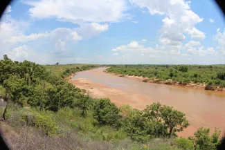
The Upper Red River: the Braided River of the Southwest
Fed by a mix of silty and sandy tributaries, the channel of the Upper Red River is in constant flux. Easily flooded, the river’s sand bars are pushed and pulled downstream with heavy spring and fall rains. When flooding resides, the main channel divides and reunites multiple times as it flows, giving it a braided appearance.
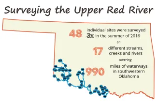
The Wildlife Department's Streams Team surveyed the every-changing river in July and August 2016, when the river was low enough to safely traverse. Working their way from the Prairie Dog Fork of the Red River near Hollis southeast to Lake Texoma near Kingston, the team took their sampling gear to 48 different sites along the river and nearby tributaries.
Backpack electrofishing units were used to capture fish in the rocky, headwater mountain streams of the Wichita Mountains, but biologists were able to use a large net to sample the fish communities in the sandy and silty-bottom streams throughout the rest of the basin. The net, or seine, was pulled through the water at least 20 times at each site to capture a variety of fish. Their catch was identified and recorded with each seine haul. Before team members moved to the next site, they also recorded information including the stream’s water depth, flow rate and temperature along with the amount of woody debris and width of the stream. This habitat data will help biologists learn more about each fish species’ preferences and may help them predict which species may be present at similar sites.
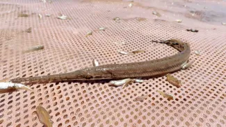
By the end of the summer, the team had sampled each of the Upper Red River sites three times and had documented 53 fish species in the 17 surveyed creeks and river ways. As expected, some of the survey sites hosted more species of fish than others.
“Diversity hotspots” for the Upper Red River basin included the East Cache Creek survey site near Lawton, where 25 species of fish were documented; the Red River site near Marietta, where 22 species were recorded; and the West Cache Creek site near Walters, where 21 species were logged.
Four of the species documented last summer are considered to be species of greatest conservation need.
To see how the current fish community compares to communities of the past, the Streams Team has been combing through past survey data, including field notes and logs from Bill Matthews and Edie Marsh-Matthews, biologists with the University of Oklahoma. Matthews and Marsh-Matthews were the last to conduct a comprehensive survey of the region in the late 1980s and have graciously shared their information with the Streams Team.
This summer, the team will continue its work surveying the state’s major drainages, focusing efforts on the Arkansas River and its tributaries. As team members move across the state sampling various rivers, they will track changes in fish distribution and document the distinct fish communities found in each ecoregion.