
Page 107 - The Freshwater Mussels of Oklahoma
P. 107
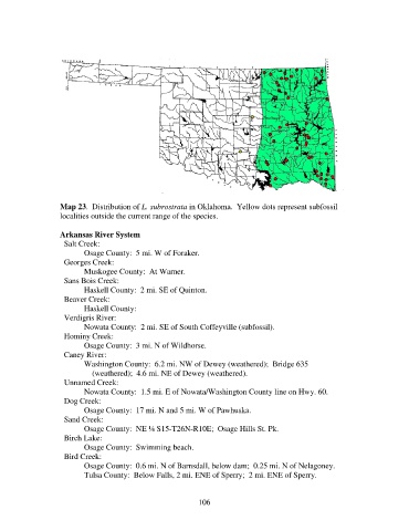
Map 23.  Distribution of L. subrostrata in Oklahoma.  Yellow dots represent subfossil
                   localities outside the current range of the species.

                   Arkansas River System
                     Salt Creek:
                          Osage County:  5 mi. W of Foraker.
                     Georges Creek:
                          Muskogee County:  At Warner.
                     Sans Bois Creek:
                          Haskell County:  2 mi. SE of Quinton.
                     Beaver Creek:
                          Haskell County:
                     Verdigris River:
                          Nowata County:  2 mi. SE of South Coffeyville (subfossil).
                     Hominy Creek:
                          Osage County:  3 mi. N of Wildhorse.
                     Caney River:
                          Washington County:  6.2 mi. NW of Dewey (weathered);  Bridge 635
                              (weathered);  4.6 mi. NE of Dewey (weathered).
                     Unnamed Creek:
                          Nowata County:  1.5 mi. E of Nowata/Washington County line on Hwy. 60.
                     Dog Creek:
                          Osage County:  17 mi. N and 5 mi. W of Pawhuska.
                     Sand Creek:
                          Osage County:  NE ¼ S15-T26N-R10E;  Osage Hills St. Pk.
                     Birch Lake:
                          Osage County:  Swimming beach.
                     Bird Creek:
                          Osage County:  0.6 mi. N of Barnsdall, below dam;  0.25 mi. N of Nelagoney.
                          Tulsa County:  Below Falls, 2 mi. ENE of Sperry;  2 mi. ENE of Sperry.


                                                            106