
Page 136 - The Freshwater Mussels of Oklahoma
P. 136
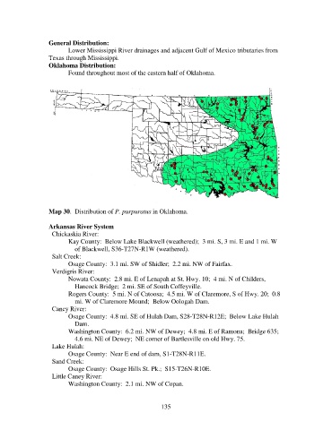
General Distribution:
                          Lower Mississippi River drainages and adjacent Gulf of Mexico tributaries from
                   Texas through Mississippi.
                   Oklahoma Distribution:
                          Found throughout most of the eastern half of Oklahoma.


                   Map 30.  Distribution of P. purpuratus in Oklahoma.

                   Arkansas River System
                     Chickaskia River:
                          Kay County:  Below Lake Blackwell (weathered);  3 mi. S, 3 mi. E and 1 mi. W
                              of Blackwell, S36-T27N-R1W (weathered).
                     Salt Creek:
                          Osage County:  3.1 mi. SW of Shidler;  2.2 mi. NW of Fairfax.
                     Verdigris River:
                          Nowata County:  2.8 mi. E of Lenapah at St. Hwy. 10;  4 mi. N of Childers,
                              Hancock Bridge;  2 mi. SE of South Coffeyville.
                          Rogers County:  5 mi. N of Catoosa;  4.5 mi. W of Claremore, S of Hwy. 20;  0.8
                              mi. W of Claremore Mound;  Below Oologah Dam.
                     Caney River:
                          Osage County:  4.8 mi. SE of Hulah Dam, S28-T28N-R12E;  Below Lake Hulah
                              Dam.
                          Washington County:  6.2 mi. NW of Dewey;  4.8 mi. E of Ramona;  Bridge 635;
                              4.6 mi. NE of Dewey;  NE corner of Bartlesville on old Hwy. 75.
                     Lake Hulah:
                          Osage County:  Near E end of dam, S1-T28N-R11E.
                     Sand Creek:
                          Osage County:  Osage Hills St. Pk.;  S15-T26N-R10E.
                     Little Caney River:
                          Washington County:  2.1 mi. NW of Copan.


                                                            135