
Page 189 - The Freshwater Mussels of Oklahoma
P. 189
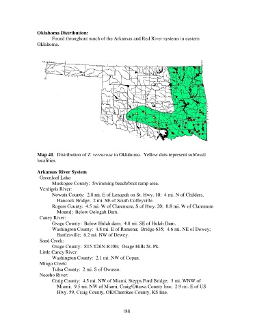
Oklahoma Distribution:
                          Found throughout much of the Arkansas and Red River systems in eastern
                   Oklahoma.


                   Map 41.  Distribution of T. verrucosa in Oklahoma.  Yellow dots represent subfossil
                   localities.

                   Arkansas River System
                     Greenleaf Lake:
                          Muskogee County:  Swimming beach/boat ramp area.
                     Verdigris River:
                          Nowata County:  2.8 mi. E of Lenapah on St. Hwy. 10;  4 mi. N of Childers,
                              Hancock Bridge;  2 mi. SE of South Coffeyville.
                          Rogers County:  4.5 mi. W of Claremore, S of Hwy. 20;  0.8 mi. W of Claremore
                              Mound;  Below Oologah Dam.
                     Caney River:
                          Osage County:  Below Hulah dam;  4.8 mi. SE of Hulah Dam.
                          Washington County:  4.8 mi. E of Ramona;  Bridge 635;  4.6 mi. NE of Dewey;
                              Bartlesville;  6.2 mi. NW of Dewey.
                     Sand Creek:
                          Osage County:  S15-T26N-R10E;  Osage Hills St. Pk.
                     Little Caney River:
                          Washington County:  2.1 mi. NW of Copan.
                     Mingo Creek:
                          Tulsa County:  2 mi. S of Owasso.
                     Neosho River:
                          Craig County:  4.5 mi. NW of Miami, Stepps Ford Bridge;  3 mi. WNW of
                              Miami;  9.5 mi. NW of Miami, Craig/Ottawa County line;  2.9 mi. E of US
                              Hwy. 59, Craig County, OK/Cherokee County, KS line.


                                                            188