
Page 61 - The Freshwater Mussels of Oklahoma
P. 61
Red River Drainage ♂ 7 68.1 64.0-71.4 111 - - subfossil
Washita River ♀ 6 71.7 69.0-75.4 95 - - subfossil
♂ 7 69.2 66.3-73.0 111 50.4 48.0-52.4
Blue River ♀ 6 70.3 66.7-74.1 95 - 53.5
♂ 2 69.1 67.6-70.6 111 55.2 51.8-58.6
Boggy River ♀ 4 71.7 69.4-73.8 107 56.5 54.1-61.5
♂ 18 68.3 63.1-75.2 117 52.0 45.8-56.4
Kiamichi River ♀ 33 74.1 68.3-80.8 98 57.7 47.7-64.8
♂ 12 66.3 62.8-70.7 114 47.7 40.8-52.1
Little River ♀ 12 72.4 67.9-77.1 94 52.7 42.9-58.9
♂ 8 66.7 61.8-70.2 102 48.5 45.5-53.2
Glover River ♀ 6 70.7 68.2-73.2 85 54.3 50.6-58.8
♂ 29 67.1 62.8-72.7 128 47.5 41.5-55.6
Mountain Fork River ♀ 26 71.2 65.4-75.4 112 53.1 46.4-64.3
General Distribution:
Upper Mississippi River drainage, Hudson Bay, Great Lakes and St. Lawrence
drainages. Introduced into several east coast Atlantic drainages.
Oklahoma Distribution:
Found generally in all the river systems of northeastern and southeastern
Oklahoma.
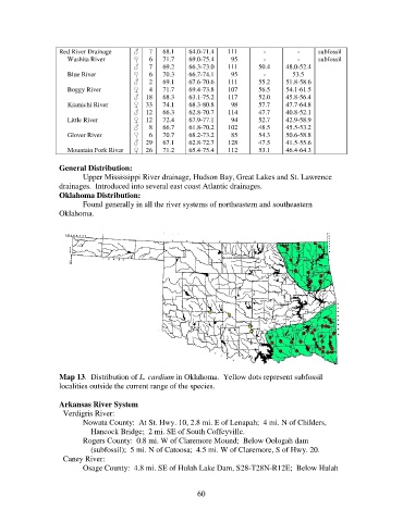
Map 13. Distribution of L. cardium in Oklahoma. Yellow dots represent subfossil
localities outside the current range of the species.
Arkansas River System
Verdigris River:
Nowata County: At St. Hwy. 10, 2.8 mi. E of Lenapah; 4 mi. N of Childers,
Hancock Bridge; 2 mi. SE of South Coffeyville.
Rogers County: 0.8 mi. W of Claremore Mound; Below Oologah dam
(subfossil); 5 mi. N of Catoosa; 4.5 mi. W of Claremore, S of Hwy. 20.
Caney River:
Osage County: 4.8 mi. SE of Hulah Lake Dam, S28-T28N-R12E; Below Hulah
60