
Page 115 - The Freshwater Mussels of Oklahoma
P. 115
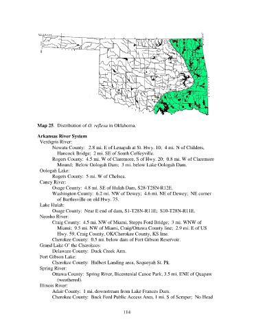
Map 25.  Distribution of O. reflexa in Oklahoma.

                   Arkansas River System
                     Verdigris River:
                          Nowata County:   2.8 mi. E of Lenapah at St. Hwy. 10;  4 mi. N of Childers,
                              Hancock Bridge;  2 mi. SE of South Coffeyville.
                          Rogers County:  4.5 mi. W of Claremore, S of Hwy. 20;  0.8 mi. W of Claremore
                              Mound;  Below Oologah Dam;  3 mi. below Lake Oologah Dam.
                     Oologah Lake:
                          Rogers County:  5 mi. W of Chelsea.
                     Caney River:
                          Osage County:  4.8 mi. SE of Hulah Dam, S28-T28N-R12E.
                          Washington County:  6.2 mi. NW of Dewey;  4.6 mi. NE of Dewey;  NE corner
                              of Bartlesville on old Hwy. 75.
                     Lake Hulah:
                          Osage County:  Near E end of dam, S1-T28N-R11E;  S10-T28N-R11E.
                     Neosho River:
                          Craig County:  4.5 mi. NW of Miami, Stepps Ford Bridge;  3 mi. WNW of
                              Miami;  9.5 mi. NW of Miami, Craig/Ottawa County line;  2.9 mi. E of US
                              Hwy. 59, Craig County, OK/Cherokee County, KS line.
                          Cherokee County:  0.5 mi. below dam of Fort Gibson Reservoir.
                     Grand Lake O’ the Cherokees:
                          Delaware County:  Duck Creek Arm.
                     Fort Gibson Lake:
                          Cherokee County:  Hulbert Landing area, Sequoyah St. Pk.
                     Spring River:
                          Ottawa County:  Spring River, Bicentenial Canoe Park, 3.5 mi. ENE of Quapaw
                              (weathered).
                     Illinois River:
                          Adair County:  1 mi. downstream from Lake Frances Dam.
                          Cherokee County:  Buck Ford Public Access Area, 1 mi. S of Scraper;  No Head


                                                            114