
Page 119 - The Freshwater Mussels of Oklahoma
P. 119
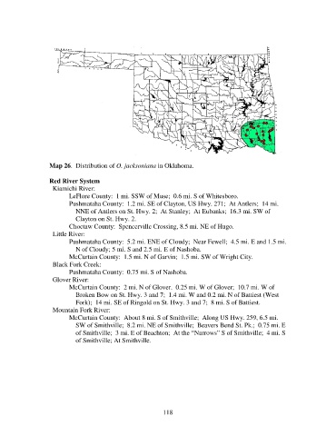
Map 26.  Distribution of O. jacksoniana in Oklahoma.

                   Red River System
                     Kiamichi River:
                          LeFlore County:  1 mi. SSW of Muse;  0.6 mi. S of Whitesboro.
                          Pushmataha County:  1.2 mi. SE of Clayton, US Hwy. 271;  At Antlers;  14 mi.
                              NNE of Antlers on St. Hwy. 2;  At Stanley;  At Eubanks;  16.3 mi. SW of
                              Clayton on St. Hwy. 2.
                          Choctaw County:  Spencerville Crossing, 8.5 mi. NE of Hugo.
                     Little River:
                          Pushmataha County:  5.2 mi. ENE of Cloudy;  Near Fewell;  4.5 mi. E and 1.5 mi.
                              N of Cloudy; 5 mi. S and 2.5 mi. E of Nashoba.
                          McCurtain County:  1.5 mi. N of Garvin;  1.5 mi. SW of Wright City.
                     Black Fork Creek:
                          Pushmataha County:  0.75 mi. S of Nashoba.
                     Glover River:
                          McCurtain County:  2 mi. N of Glover.  0.25 mi. W of Glover;  10.7 mi. W of
                              Broken Bow on St. Hwy. 3 and 7;  1.4 mi. W and 0.2 mi. N of Battiest (West
                              Fork);  14 mi. SE of Ringold on St. Hwy. 3 and 7;  8 mi. S of Battiest.
                     Mountain Fork River:
                          McCurtain County:  About 8 mi. S of Smithville;  Along US Hwy. 259, 6.5 mi.
                              SW of Smithville;  8.2 mi. NE of Smithville;  Beavers Bend St. Pk.;  0.75 mi. E
                              of Smithville;  3 mi. E of Beachton;  At the “Narrows” S of Smithville;  4 mi. S
                              of Smithville; At Smithville.


                                                            118