
Page 142 - The Freshwater Mussels of Oklahoma
P. 142
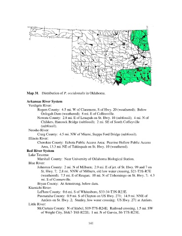
Map 31.   Distribution of P. occidentalis in Oklahoma.

                   Arkansas River System
                     Verdigris River:
                          Rogers County:  4.5 mi. W of Claremore, S of Hwy. 20 (weathered);  Below
                              Oologah Dam (weathered);  8 mi. E of Collinsville.
                          Nowata County:  2.8 mi. E of Lenapah on St. Hwy. 10 (subfossil);  4 mi. N of
                              Childers, Hancock Bridge (subfossil);  2 mi. SE of South Coffeyville
                              (subfossil).
                     Neosho River:
                          Craig County:  4.5 mi. NW of Miami, Stepps Ford Bridge (subfossil).
                     Illinois River:
                          Cherokee County:  Echota Public Access Area;  Peavine Hollow Public Access
                              Area, 13.3 mi. NE of Tahlequah on St. Hwy. 10 (weathered).
                   Red River System
                     Lake Texoma:
                          Marshall County:  Near University of Oklahoma Biological Station.
                     Blue River:
                          Johnston County:  2 mi. N of Milburn;  2.9 mi. E of jct. of St. Hwy. 99 and 7 on
                              St. Hwy. 7;  2.8 mi. NNW of Milburn, old low water crossing, S21-T3S-R7E
                              (weathered);  7.5 mi. E of Reagan;  10 mi. N of Tishomingo on St. Hwy. 7;  4.3
                              mi. S of Connerville.
                          Bryan County:  At Armstrong, below dam.
                     Kiamichi River:
                          LeFlore County:  0.6 mi. S of Whitesboro, S33-34-T3N-R23E.
                          Pusmataha County:  0.9 mi. S of Clayton on US Hwy. 271;  14.9 mi. NNE of
                              Antlers on St. Hwy. 2;  Stanley, low water crossing;  US Hwy. 271 at Antlers.
                     Little River:
                          McCurtain County:  N of Idabel, S19-T7S-R24E;  Railroad crossing, 1.5 mi. SW
                              of Wright City, S6&7-T6S-R22E;  1 mi. N of Garvin, S6-T7S-R23E.


                                                            141