
Page 179 - The Freshwater Mussels of Oklahoma
P. 179
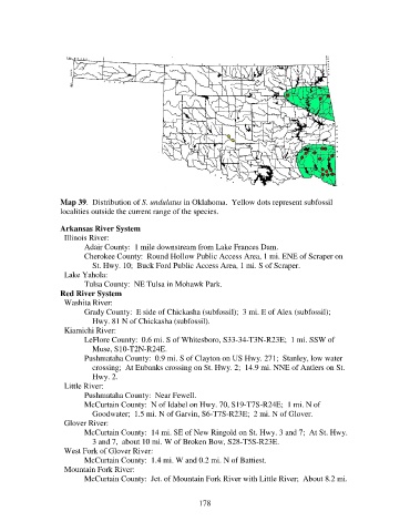
Map 39.  Distribution of S. undulatus in Oklahoma.  Yellow dots represent subfossil
                   localities outside the current range of the species.

                   Arkansas River System
                     Illinois River:
                          Adair County:  1 mile downstream from Lake Frances Dam.
                          Cherokee County:  Round Hollow Public Access Area, 1 mi. ENE of Scraper on
                              St. Hwy. 10;  Buck Ford Public Access Area, 1 mi. S of Scraper.
                     Lake Yahola:
                          Tulsa County:  NE Tulsa in Mohawk Park.
                   Red River System
                     Washita River:
                          Grady County:  E side of Chickasha (subfossil);  3 mi. E of Alex (subfossil);
                              Hwy. 81 N of Chickasha (subfossil).
                     Kiamichi River:
                          LeFlore County:  0.6 mi. S of Whitesboro, S33-34-T3N-R23E;  1 mi. SSW of
                              Muse, S10-T2N-R24E.
                          Pushmataha County:  0.9 mi. S of Clayton on US Hwy. 271;  Stanley, low water
                              crossing;  At Eubanks crossing on St. Hwy. 2;  14.9 mi. NNE of Antlers on St.
                              Hwy. 2.
                     Little River:
                          Pushmataha County:  Near Fewell.
                          McCurtain County:  N of Idabel on Hwy. 70, S19-T7S-R24E;  1 mi. N of
                              Goodwater;  1.5 mi. N of Garvin, S6-T7S-R23E;  2 mi. N of Glover.
                     Glover River:
                          McCurtain County:  14 mi. SE of New Ringold on St. Hwy. 3 and 7;  At St. Hwy.
                              3 and 7,  about 10 mi. W of Broken Bow, S28-T5S-R23E.
                     West Fork of Glover River:
                          McCurtain County:  1.4 mi. W and 0.2 mi. N of Battiest.
                     Mountain Fork River:
                          McCurtain County:  Jct. of Mountain Fork River with Little River;  About 8.2 mi.


                                                            178