
Page 51 - The Freshwater Mussels of Oklahoma
P. 51
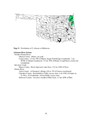
Map 11.  Distribution of E. dilatata in Oklahoma.

                   Arkansas River System
                     Neosho (Grand) River:
                          Ottawa County:  Miami, city park.
                          Craig County:  4.5 mi. NW of Miami, Stepps Ford Bridge (weathered);  3 mi.
                              WNW of  Miami (weathered);  9.5 mi. NW of Miami, Craig/Ottawa county line
                              (weathered).
                     Spavinaw Creek:
                          Mayes County:  Below Spavinaw Lake Dam, 15.5 mi. ENE of Pryor.
                     Illinois River:
                          Adair County:  At Hampton’s Bridge, 0.8 mi. W of Chewey (weathered).
                          Cherokee County:  Round Hollow Public Access Area, 1 mi. ENE of Scaper on
                              St. Hwy. 10 (weathered);  Echota Public Access Area.
                          Delaware County:  Just above mouth of Flint Creek, 1.3 mi. SSW of Flint.


                                                             50