
Page 23 - ODO 2024 JanFeb online version
P. 23
Studies documenting when and where animals move can significantly contrib-
ute to understanding of fish and wildlife on local, national, and even internation-
al levels. Today’s ability to map and animate an animal’s movements through
time is visually hard to beat. But the data behind the map wouldn’t exist without
a series of questions and technolog-
ical advances that began more than
200 years ago.
Since one of the first document- TIM PATTON/SE OKLAHOMA STATE UNIV.
ed migration experiments in North
America in the early 1800s, this field
of study has moved from threads
being tied to the legs of eastern
phoebes to packages of location
data being digitally transmitted from
tagged animals and displayed on
real-time, interactive maps.
In Oklahoma, wildlife studies have
used multiple forms of telemetry
technology. Classic examples include
research teams hiking up sand dunes
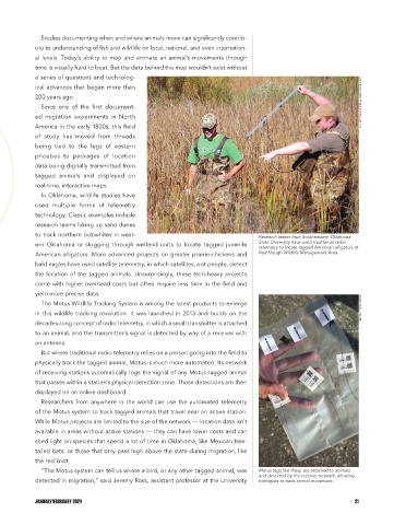
to track northern bobwhites in west- Research teams from Southeastern Oklahoma
ern Oklahoma or slogging through wetland units to locate tagged juvenile State University have used traditional radio
telemetry to locate tagged American alligators at
American alligators. More advanced projects on greater prairie-chickens and Red Slough Wildlife Management Area.
bald eagles have used satellite telemetry, in which satellites, not people, detect
the location of the tagged animals. Unsurprisingly, these tech-heavy projects
come with higher overhead costs but often require less time in the field and
yield more precise data.
The Motus Wildlife Tracking System is among the latest products to emerge BETSEY YORK/ODWC
in this wildlife tracking revolution. It was launched in 2013 and builds on the
decades-long concept of radio telemetry, in which a small transmitter is attached
to an animal, and the transmitter’s signal is detected by way of a receiver with
an antenna.
But where traditional radio telemetry relies on a person going into the field to
physically track the tagged animal, Motus is much more automated. Its network
of receiving stations automatically logs the signal of any Motus-tagged animal
that passes within a station’s physical detection zone. Those detections are then
displayed on an online dashboard.
Researchers from anywhere in the world can use the automated telemetry
of the Motus system to track tagged animals that travel near an active station.
While Motus projects are limited to the size of the network — location data isn’t
available in areas without active stations — they can have lower costs and can
shed light on species that spend a lot of time in Oklahoma, like Mexican free-
tailed bats, or those that only pass high above the state during migration, like
the red knot.
“The Motus system can tell us where a bird, or any other tagged animal, was Motus tags like these are attached to animals
and detected by the receiver network, allowing
detected in migration,” said Jeremy Ross, assistant professor at the University biologists to track animal movement.
JANUARY/FEBRUARY 2024 21