
Page 261 - Interp Book
P. 261
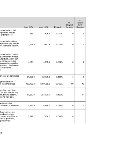
No.
                                                                           No.      Ground
                                                                         Original     truth
 Mapped Type Name   Brief Description   Area (HA)   Area (AC)   Percent   Samples   Samples
 This type is mapped along first and second order streams within narrow buffers, and
 Southeastern Great   may circumscribe a variety of herbaceous wetlands.  Common components include
 Plains: Riparian   sedge and rush species, spikerush species, cattails, smartweeds, and moist-soil   335.1   828.0   0.002%   0   0
 Herbaceous Wetland
 grasses.
 Southeastern Great   This type is mapped along first and second order streams within narrow buffers where
 Plains: Riparian   eastern redcedar is among the most important species.  Other components may include   1,172.5   2,897.3   0.006%   0   0
 Mixed Evergreen -   species such as green ash, gum bumelia, possumhaw, honeylocust, hackberry species,
 Hardwood Woodland   black walnut, willow species, Osage orange, and elm species.


 This type is mapped along first and second order streams within narrow buffers, and is
 represented by vegetation influenced by a variety of water regimes and human impacts.
 Southeastern Great   Common shrubs or small trees include willow species, common buttonbush, green ash,
 Plains: Riparian   winged elm, gum bumelia, sugar hackberry, boxelder, possumhaw, honeylocust, and   4,285.1   10,588.6   0.024%   2   0
 Shrubland and   Osage orange.  Vines such as eastern poison ivy, grape species, peppervince species,
 Young Woodland   Virginia creeper, and greenbriar species may be conspicuous components.  Herbaceous
 species many include species such as field brome, Bermudagrass, little barley,
 cheatgrass, western ragweed, Virginia wildrye, and sedge species.


 This type consists of built-up areas and wide transportation corridors that are dominated
 Urban High Intensity         21,359.0         52,779.3       0.118%            0          0
 by impervious cover.
 This type includes areas that are built-up or partially cleared of vegetation but not
 Urban Low Intensity   entirely covered by impervious cover, and includes most of the non-industrial areas   489,168.3   1,208,759.2   2.702%   69   12
 within cities and towns.
 This type circumscribes forests that are mainly in a variety of states of recovery from
 West Gulf Coastal   human disturbance, and over a variety of soil moisture regimes.  Common species may
 Plain: Dry Upland   include white oak, southern red oak, post oak, water oak, sweetgum, hickory species,   90,260.9   223,039.1   0.499%   7   11
 Hardwood Forest   sugar hackberry, elm species, and green ash.  Loblolly or shortleaf pine may be a
 component.

 West Gulf Coastal   These areas were essentially unvegetated during all seasons at the time of data
 Plain: Large River   acquisition (circa 2012), and may represent river-scoured islands, riverbeds, and stream   2,629.9   6,498.7   0.015%   0   0
 Bottomland Barrens   edges.

 This type is mapped on bottomland soils across a variety of hydrologic regimes and
 West Gulf Coastal   various stages of disturbance.  They generally represent successional pastures or
 Plain: Large River   woodland edges,that could not be confirmed as clear-cuts based on data from 2000 to   3,198.7   7,904.1   0.018%   0   1
 Bottomland   2012.  Common species may include winged elm, common buttonbush, green ash,
 Deciduous Shrubland
 sugar hackberry, green ash, honeylocust, baccharis species, and possumhaw.


 228