
Page 94 - The Freshwater Mussels of Oklahoma
P. 94
Lake Murray 4 62.0-71.8 65.4 115 33.8-37.2 34.4
Blue River 4 58.2-69.8 65.4 118 33.1-35.5 34.0
Muddy Boggy River 20 59.1-70.8 64.5 130 29.6-43.5 35.3 4 with rays
Atoka Reservoir 9 54.2-63.3 60.2 41 25.0-30.6 28.1 all rayed
Kiamichi River 18 58.9-68.8 63.8 93 32.6-39.6 36.4 2 with rays
Little River 7 58.1-66.0 63.1 106 35.2-41.1 38.0
General Distribution:
Mississippi River drainage, parts of Great Lakes and St. Lawrence drainages and
some eastern and western Gulf of Mexico drainages from Texas through Alabama.
Oklahoma Distribution:
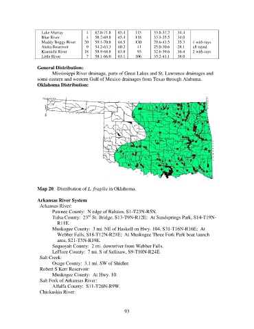
Map 20. Distribution of L. fragilis in Oklahoma.
Arkansas River System
Arkansas River:
Pawnee County: N edge of Ralston, S1-T23N-R5N.
rd
Tulsa County: 23 St. Bridge, S13-T9N-R12E; At Sandsprings Park, S14-T19N-
R11E.
Muskogee County: 3 mi. NE of Haskell on Hwy. 104, S31-T16N-R16E; At
Webber Falls, S18-T12N-R21E; At Muskogee Three Fork Park boat launch
area, S21-T5N-R19E.
Sequoyah County: 2 mi. downriver from Webber Falls.
LeFlore County: 7 mi. S of Sallisaw, S9-T10N-R24E.
Salt Creek:
Osage County: 3.1 mi. SW of Shidler.
Robert S Kerr Reservoir:
Muskogee County: At Hwy. 10.
Salt Fork of Arkansas River:
Alfalfa County: S11-T26N-R9W.
Chickaskia River:
93