
Page 18 - Interp Book
P. 18
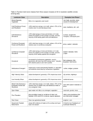
Table 2. Fourteen land cover classes from three season mosaics of 30 m resolution satellite remote
               sensing data.

                   Landcover Class                     Description                    Examples from Phase 1

                Barren/Sparsely        little or no vegetation year-round           river beds, quarries, areas
                Vegetated                                                           cleared for development


                Cold Deciduous Forest   >25% total tree canopy (>4 m tall), where >75% of the
                and Woodland           relative cover is cold deciduous trees       oaks, hackberry, elm, ash


                                       >25% total canopy of trees and shrubs (<4 m tall),
                Cold Deciduous         where the majority of the canopy is shrubs, and the   sumacs, winged elm,
                Shrubland                                                           mesquite, Chickasaw plum
                                       majority of the woody plants are cold deciduous


                Coniferous Evergreen   >25% total tree canopy (>4 m tall), where >75% of the   pines, eastern redcedar
                Forest and Woodland    relative cover is coniferous evergreen


                                       >25% total canopy of trees and shrubs (<4 m tall),
                Coniferous Evergreen                                                eastern redcedar, Ashe
                Shrubland              where the majority of the canopy is shrubs, and the   juniper
                                       majority of the woody species are evergreen


                                       dominated by herbaceous vegetation, usually
                Grassland              graminoid, with less than 25% woody cover.  Includes   Bermudagrass, little
                                                                                    bluestem, field brome
                                       both planted pasture and native prairie.


                                       seasonally or semi-permanently flooded, or  saturated
                Herbaceous Emergent                                                 rushes, sedges, grasses
                                       soil wetlands dominated by herbaceous vegetation

                High Intensity Urban   urban development, generally >70% impervious cover   city centers, highways


                Low Intensity Urban    urban development, generally <70% impervious cover   residential areas


                Mixed Cold Deciduous /   >25% total tree canopy (>4 m tall), where >75% of the   oaks with eastern redcedar or
                Evergreen Forest and   relative cover is neither only cold deciduous trees or   pines
                Woodland               only evergreen trees

                Open Water             open water with little or no emergent vegetation   reservoirs, ponds, rivers

                                       pine plantation based on evidence of clear cuts   loblolly pine plantations that
                Pine Planation
                                       between 2000 and 2012 or dense, regular signature   are intensively managed

                Row Crops              Row crop agricultural lands                  sorghum, corn

                Seasonally Flooded     areas with evidence of water at the surface during at   limited to river floodplains of
                Bottomland             least one season                             southeast Oklahoma


                                                             10