
Page 25 - Interp Book
P. 25
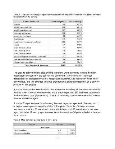
Table 3.  Total Use's Accuracy and per-class accuracy for land cover classification.  Full confusion matrix
               is available from the authors.

                          Land Cover Class             Total Samples     Users Accuracy
                barren                                             133             91.7%
                deciduous woodland                                 536             90.2%
                deciduous shrubland                                357             60.2%
                rowcorp agriculture                                334             91.2%
                evergreen shrubland                                 84             66.1%
                herbaceous                                        1313             91.2%
                coniferous evergreen woodland                      208             85.3%
                water                                              169             97.9%
                high intensity urban                                77             90.9%
                low intensity urban                                172             82.5%
                herbaceous wetland                                  56             68.8%
                mixed evergreen-deciduous woodland                 121             59.5%
                bottomland deciduous woodland                       36             64.8%
                Havard shin oak shinnery                            90             75.4%
                           Total Samples & Accuracy               3682           85.00%


               The ground-collected data, plus existing literature, were also used to draft the short
               descriptions contained in the body of this document.  More complete, technical
               descriptions of ecological systems, mapping subsystems, and vegetation types were
               also drafted, and this 69-page text was provided as a separate document as a delivery
               product for this project.

               A total of 493 species were found in plots statewide, including 82 that were recorded in
               the tree layer, 130 that were recorded in the shrub layer, and 357 that were recorded in
               the herbaceous layer (Appendix 1).  A total of 76 woody species were recorded in both
               the tree and shrub layers.


               A total of 85 species were found among the most important species in the tree, shrub,
               or herbaceous layers in more than 50 of 3,714 plots (Table 4).  Of these, 41 were
               herbaceous species, 33 were found in the shrub layer, and 28 were found in the tree
               layer.  A total of 17 woody species were found in more than 50 plots in both the tree and
               shrub layers.

               Table 4.  Most common species found in 3,714 plots.

                                Species                     # of plots    Percent
                                            Tree Layer
                Quercus stellata                              618          16.7%
                Quercus marilandica                           379          10.2%

                                                             17