
Maps (OLAP)
Document
Document
Maps for Individual Properties (shown below)
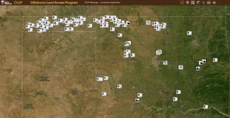
The interactive OLAP Map Directory can be accessed via desktop, tablet, or mobile devices. The app includes real-time maps of OLAP walk-in areas, including details such as parking areas, boundaries, access type, access dates, habitat descriptions, possible species present, and photographs. These maps will be updated by 6:00 pm of the preceding day to reflect the temporary closure of specific walk-in areas.
Please note that the only accurate, up-to-date digital mapping service available for the OLAP is the OLAP Map Directory administered by the ODWC. Third-party apps display static information that may be weeks out of date. Sportspersons are strongly advised to use the OLAP Map Directory as a primary source of information for Walk-in Areas.
ArcGIS Field Maps for Smartphones and Tablets
Use the free ArcGIS Field Maps App to bring the OLAP Walk-in Areas to your mobile device (data signal required). Once the app is installed on your device, search the Maps for "OLAP" and select Public OLAP Web Map".
Please note: This app requires a cellular signal. This is the best option for viewing the OLAP Map Directory in the field.
Download the app from the Apple App Store or Google Play.
PDF Files for Printing
Updated PDFs will be added soon. Check back at a later time.
- Central Region
Hunting:
DocumentDocumentDocumentDocumentDocument- Northeast Region
Fishing:
DocumentHunting:
Document- Northwest Region
Fishing:
DocumentHunting:
DocumentDocumentDocumentDocumentDocumentDocumentDocumentDocumentDocumentDocumentDocumentDocumentDocumentDocumentDocumentDocumentDocumentDocumentDocumentDocumentDocumentDocumentDocumentDocumentDocumentDocumentDocumentDocumentDocumentDocumentDocumentDocumentDocumentDocumentDocumentDocumentDocumentDocumentDocumentDocumentDocumentDocumentDocumentDocumentDocumentDocumentDocumentDocumentDocumentDocumentDocumentDocumentDocumentDocumentDocumentDocumentDocumentDocumentDocumentDocumentDocumentDocumentDocumentDocumentDocumentDocumentDocumentDocumentDocumentDocument- Panhandle
Hunting:
DocumentDocumentDocumentDocumentDocumentDocumentDocumentDocumentDocumentDocumentDocumentDocumentDocumentDocumentDocumentDocumentDocumentDocumentDocumentDocumentDocumentDocumentDocumentDocumentDocumentDocumentDocumentDocumentDocumentDocumentDocumentDocumentDocumentDocumentDocumentDocumentDocumentDocumentDocumentDocumentDocumentDocumentDocumentDocumentDocumentDocumentDocumentDocumentDocumentDocumentDocumentDocumentDocumentDocumentDocumentDocumentDocumentDocumentDocumentDocumentDocumentDocumentDocumentDocumentDocumentDocumentDocumentDocumentDocumentDocumentDocumentDocumentDocumentDocumentDocumentDocumentDocumentDocumentDocumentDocumentDocumentDocumentDocumentDocument- Southeast
Fishing:
DocumentDocumentDocumentDocumentHunting:
DocumentDocumentDocumentDocumentDocumentDocumentDocument- Southwest
Fishing:
DocumentHunting:
DocumentDocumentDocumentDocumentDocumentDocumentDocumentDocumentDocument