Oklahoma Land Access Program
The Wildlife Department partners with private landowners to create even more public hunting and fishing access through the Oklahoma Land Access Program. Landowners are rewarded for conservation-minded practices and hunters and anglers have even more places to go. Everyone wins.
ATTENTION Cimarron, Texas, Woodward, Major, and Woods County Hunters!
To monitor CWD presence, hunters should read the Selective Surveillance Area (SSA) rules and regulations.
SSA Rules & Regulations
- How OLAP Benefits Sportspersons
The OLAP provides hunting opportunities throughout the state in a variety of different habitat types. Our goal is to provide users with the opportunity to pursue multiple different species across Oklahoma. Whether you hunt small game, doves, upland game, waterfowl, or deer the OLAP offers chances to chase them all. There are also several different spots to go fishing, which include ponds, streams, and small lakes.
Properties in OLAP are not owned by ODWC; instead ODWC pays a lease price annually. While ODWC has grant funds to help pay these leases, some Wildlife Department funds are still required as match for these grants. To cover these match funds, The Wildlife Department has implemented a Land Access Permit requirement for OLAP properties, similar to Honobia Creek, Three Rivers, and Herron Family WMAs (which are also leased properties). In addition, a hunting and/or fishing license is required, unless a person is exempt.
A core principle of the OLAP is to increase walk-in access opportunities for hunting, fishing, stream access, and wildlife viewing. This goal compliments a main tenant of the North American Conservation Model: that every citizen has an opportunity, under the law, to hunt and fish. The democratic foundation of this conservation model has made it the most successful in the world, and the OLAP seeks to increase access for multiple opportunities throughout the state.
- How OLAP Benefits Landowners
The OLAP is designed to give landowners the flexibility to maintain their current farming or ranching practices while providing outdoor recreational opportunities. Enrolled landowners will be compensated based on enrolled acres, location, access type, and contract length. Additional compensation is available for properties enrolled in conservation programs, such as WHIP, CRP, or EQIP to further reward landowners making efforts to conserve and sustain wildlife.
Almost anyone who owns or leases land can qualify, and ideal properties include CRP-enrolled grassland, native rangeland, weedy crop stubble, forests, riparian corridors, wetland areas, and wildlife-friendly field buffers. Once enrolled, property boundaries are posted with signs, and parking areas (if present) will have informational signs indicating access dates and allowed activities. Enrolled landowners are accorded limited liability by existing state laws, and game wardens will periodically patrol OLAP properties.
Landowners retain the right to temporarily deny access while ranching or agricultural activities are occurring. Access is limited to foot traffic only, and vehicles are prohibited. Properties in OLAP are not owned by ODWC; instead ODWC pays a lease price annually.
Landowners interested in enrolling can fill out an application and/or contact the OLAP biologist or technician for assistance with the application process. To qualify, the applicant must be the legal owner of record, representing the legal owner of record, or lessee with operational authority of proposed land for the extent of the contract. Applicant’s land must be accessible from a public road. The minimum parcel size for hunting properties is 40 acres.
Another core principle of the OLAP is to include and reward conservation-minded landowners. American conservationist Aldo Leopold said that “Conservation will ultimately boil down to rewarding the private landowner who conserves the public interest.”
- History of the Oklahoma Land Access Program
Administered by the Oklahoma Department of Wildlife Conservation, the OLAP provides financial incentives to landowners who allow public access for hunting, fishing, stream access, and wildlife viewing opportunities on private lands. It began when the Wildlife Department received a $2.26 million dollar grant from the U.S. Department of Agriculture as part of the 2014 Farm Bill, through the Voluntary Public Access – Habitat Incentive Program (VPA-HIP). VPA-HIP programs are successful at simultaneously rewarding conservation on private lands and providing more opportunities for sportspersons.
In 2023, the current Farm Bill expired, and additional funds were then required to continue to keep the program running. To make up for the reduction in federal funds, the Wildlife Department had to switch to State funds. These funds are acquired by requiring users to purchase a Land Access Permit to access OLAP properties. This permit also provides access to Honobia Creek, Three Rivers, and Herron Family WMAs.
In 2025, the Wildlife Department partnered with Pheasants Forever and Quail Forever’s (PFQF) Public Access to Habitat (PATH) initiative to provide Oklahoma sportspersons access to more high-quality upland habitat. This partnership comes in the form of financial assistance, with the goal of acquiring 10,000 new acres in the first two years. Since then, the ODWC has continued to expand, grow, and improve the program to add additional opportunities for Oklahoma sportspersons.
How to Access OLAP Properties
A Land Access Permit is required to access all OLAP properties.
To purchase a Land Access Permit go to GoOutdoorsOklahoma.com and search for "Land Access Permit" under Licensing.
Funds from the sale of this permit will be used as match for the federal funding grant for the program.
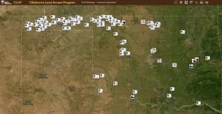
Finding a place to hunt or fish starts with the OLAP map directory. You can zoom in and click on each boundary to see the access type, species present, type of cover or habitat, and total acreage of each property. Once you have decided which property you wish to visit, make sure you have an up-to-date hunting license and a land access permit (unless exempt).
When visiting an OLAP property, it is important to understand OLAP’s general regulations. OLAP functions differently than private land and Wildlife Management Areas, so it is important to understand those differences before accessing a property.
OLAP is broken down into several different access types, each with its own set of regulations and allowable activities:
- Walk-in Hunting Area: Archery/Shotgun Only
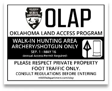
These areas make up the majority of properties enrolled in the OLAP and do not require check-in beforehand to access. Open to all hunting seasons besides elk season, hunters may access these properties from September 1st – May 16th. Hunters may pursue game with archery equipment or shotgun (not shot size larger than T shot); centerfire rifles or pistols (arrow rifles are considered rifles), rimfire rifles or pistols, and muzzleloaders are prohibited.
*** Online check-in is not required.
- Limited Access
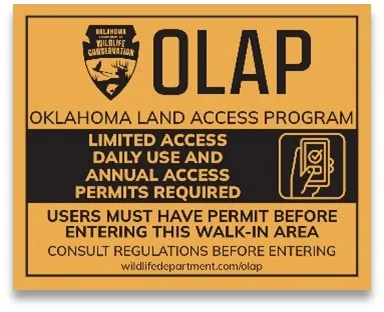
Online check-in required before accessing these properties. Restricts the number of hunters that may access a property at a given time, which provides a better experience to hunters and property owners in high-traffic areas. Open to all hunting seasons besides elk season, hunters may access these properties from September 1st – May 16th. Hunters may pursue game with archery equipment or shotgun (not shot size larger than T shot); centerfire rifles or pistols (arrow rifles are considered rifles), rimfire rifles or pistols, and muzzleloaders are prohibited.
Limited Access walk-in areas are subject to the same regulations as Archery/Shotgun Only walk-in areas.
Additional Information:
- Limited Access is now a daily check-in (no more drawings) on a first-come, first-serve basis.
- Check-in for a specific day opens 2 days before that day at 8:00 am.
- The number of available spots will shift according to the hunting season. For example, a tract might allow more hunters on the tract during dove season in September versus duck season in December.
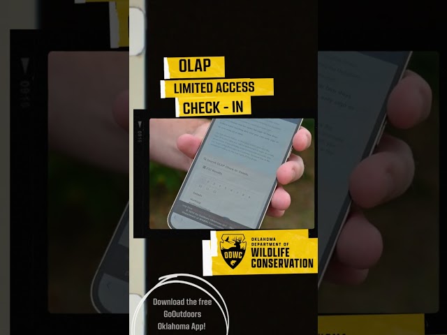
Check-in (Limited Access Only)
 Image
Image
Check-in is required if you see this icon in the area where you plan to hunt.
The accompanying video shows how to access property with limited access that are part of the Oklahoma Land Access Permit or walk-in areas that allow you to hunt private lands for free.
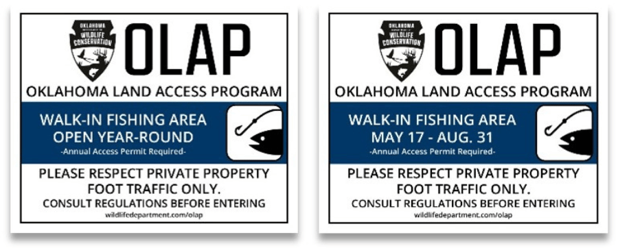
- Walk-in Fishing Area
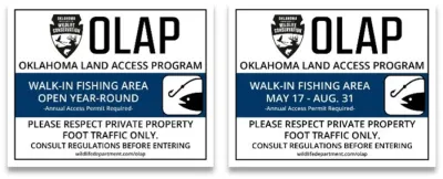
Catch and release fishing only. No more than three rods per person and three hooks per line. Seasonal fishing areas are available on some currently enrolled Walk-in Hunting Areas and open up to public fishing after the hunting season from May 17th – August 31st. Annual Fishing Areas are open year-round.
*** Online check-in is not required.
- Walk-in Stream Area
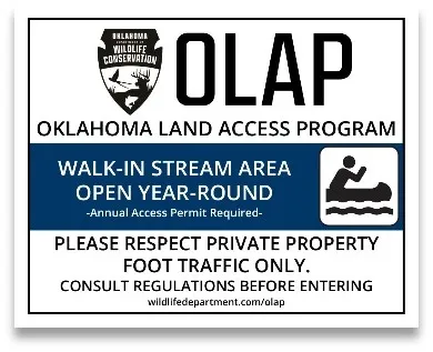
Stream access areas provide the public access to a stream corridor for fishing, swimming and/or launching/retrieving non-motorized boats. Sportspersons must remain in the designated stream corridor. These areas are open year-round.
*** Online check-in is not required.
- Wildlife Viewing Area
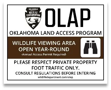
Available to the public for non-hunting activities. These areas are open year-round for viewing wildlife or hiking. Trapping, hunting, and fishing are prohibited, unless designated otherwise.
*** Online check-in is not required.
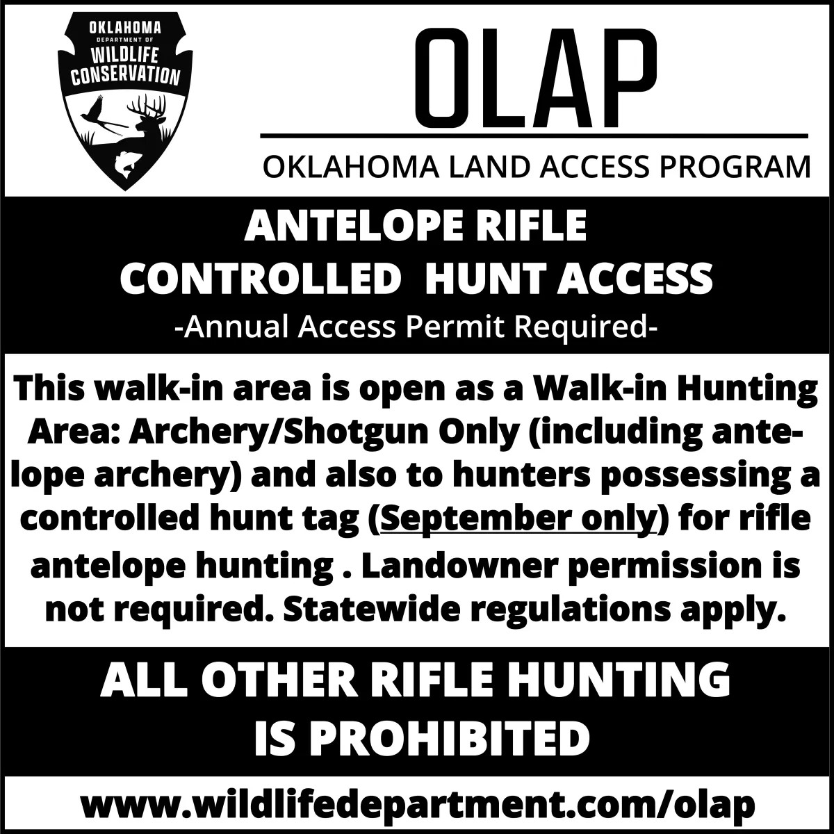
- Controlled Hunt: Antelope
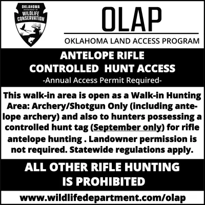
The Antelope Rifle Controlled Hunt Access properties provide access for hunters drawn through the controlled hunts applications.


OLAP Map Directory
This material is based upon work supported by the Natural Resources Conservation Service, U.S. Department of Agriculture, under number 69-3A75-16-513. All opinions, findings, conclusions, or recommendations expressed in this publication are those of the author(s) and do not necessarily reflect the views of the U.S. Department of Agriculture.