Current Opportunities for Public Comment
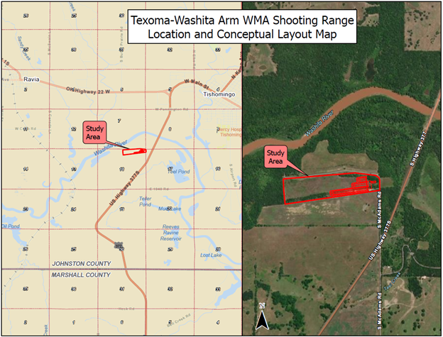
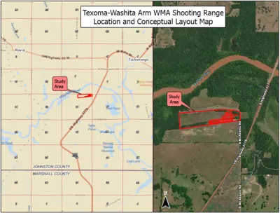
- Texoma/Washita WMA Shooting Range
Location: Texoma/Washita WMA Shooting Range
Location Coordinates: 34°12'54.7"N 96°42'21.2"W
Purpose: To provide an opportunity for the public to comment, identify specific issues, and/or environmental impacts that can be addressed in the Draft Environmental Assessment for the Oklahoma Department of Wildlife Conservation (ODWC).
Need: The proposed need is to complete an environmental assessment (EA) including environmental studies and to arrive at either a Finding of No Significant Impact (FONSI) or complete an Environmental Impact Study (EIS) pursuant to the National Environmental Policy Act (NEPA) for the project described below:
Renovation and expansion of the existing shooting range on Texoma-Washita WMA located in Johnston County, Oklahoma. The Texoma-Washita WMA shooting range study area is approximately 35 acres in size, located south of the Washita River, approximately one mile southwest of Tishomingo, Oklahoma and west of U.S. Route 377, off South McAdams Road (N3540 Road) in Section 18, Township 4S, Range 6E.
Proposed plans may include improving and expanding the existing 100-yard rifle range, adding an additional 100-yard rifle range, and adding a 50-yard pistol range with covered metal shooting stations including shooting benches/tables, safety berms, backstops, archery range, restrooms, gates, fencing, and associated parking lots. All range components will include ADA parking and access.
Estimated timeline to complete an environmental assessment, engineering, and construction is 3-5 years.
The shooting range is located on property owned by the U.S. Army Corps of Engineers (USACE), under license for operations and management by the ODWC, and funded by the ODWC and United States Fish and Wildlife Service (USFWS).
Comment Deadline:
Written comments to be provided or postmarked by March 31, 2025, via email, poll, mail, or social media comments.
Submit comments via email to: Amanda.thomas@odwc.ok.gov
Submit comments via mail to:
Oklahoma Department of Wildlife Conservation
Attn: Shooting Range Coordinator
P.O. Box 53465, Oklahoma City, OK 73152
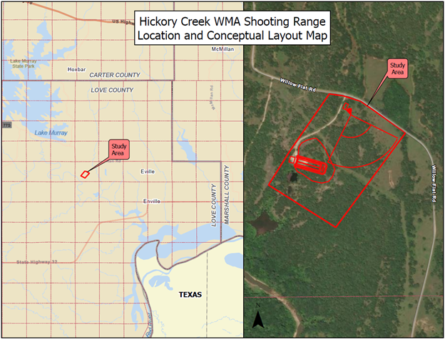
- Hickory Creek WMA Shooting Range
Location: Hickory Creek WMA Shooting Range
Location Coordinates: 34° 0'13.44"N 97° 2'1.64"W
Purpose: To provide an opportunity for the public to comment, identify specific issues, and/or environmental impacts that can be addressed in the Draft Environmental Assessment for the Oklahoma Department of Wildlife Conservation (ODWC).
Need: The proposed need is to complete an environmental assessment (EA) including environmental studies and to arrive at either a Finding of No Significant Impact (FONSI) or complete an Environmental Impact Study (EIS) pursuant to the National Environmental Policy Act (NEPA) for the project described below:
Renovation and expansion of the existing shooting range on Hickory Creek WMA located in Love County, Oklahoma. The Hickory Creek WMA shooting range study area is approximately 40 acres in size, located southeast of Lake Murray, approximately 7 miles east of Marietta, Oklahoma and south of Willow Flat Road in Section 30, Township 6S, Range 3E.
Proposed plans may include improving and expanding the existing 80-yard rifle range, including covered metal shooting stations including shooting benches/tables, safety berms, backstops, a shotgun/trap range, restrooms, gates, fencing, and associated parking lots. All range components will include ADA parking and access.
Estimated timeline to complete an environmental assessment, engineering, and construction is 3-5 years.
The shooting range is located on property owned by the U.S. Army Corps of Engineers (USACE), under license for operations and management by the ODWC, and funded by the ODWC and United States Fish and Wildlife Service (USFWS).
Comment Deadline:
Written comments to be provided or postmarked by March 31, 2025, via email, poll, mail, or social media comments.
Submit comments via email to: Amanda.thomas@odwc.ok.gov
Submit comments via mail to:
Oklahoma Department of Wildlife Conservation
Attn: Shooting Range Coordinator
P.O. Box 53465, Oklahoma City, OK 73152

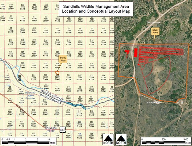
- Sandhills WMA Shooting Range
Location: Sandhills WMA Shooting Range
Location Coordinates: 36.43407853674648, -98.6505662042595
Purpose: To provide an opportunity for the public to comment, identify specific issues, and/or environmental impacts that can be addressed in the Draft Environmental Assessment for the Oklahoma Department of Wildlife Conservation (ODWC).
Need: The proposed need is to complete an environmental assessment (EA) including environmental studies and to arrive at either a Finding of No Significant Impact (FONSI) or complete an Environmental Impact Study (EIS) pursuant to the National Environmental Policy Act (NEPA) for the project described below:
The construction of a new shooting range on Sandhills WMA, located north of the Cimarron River, approximately 12 miles west of Cleo Springs, Oklahoma and located on County Road 450 in Section 36, Township 23N, Range 14W.
Proposed plans may include a 200- to 300-yard rifle range, a 100-yard rifle range, and a 25-yard pistol range with covered metal shooting stations including shooting benches/tables, safety berms, and backstops, a shotgun trap range, an archery tower/range, access roads, parking lots, gates, fencing, ADA parking and pathways, restrooms, and borrow areas.
Estimated timeline to complete an environmental assessment, engineering, and construction is 3-5 years.
The shooting range is located on property owned by the Oklahoma Department of Wildlife Conservation (ODWC) and the project is funded by the ODWC and United States Fish and Wildlife Service (USFWS).
Comment Deadline:
Written comments to be provided or postmarked by April 15, 2025, via email, poll, mail, or social media comments.
Submit comments via email to: Amanda.thomas@odwc.ok.gov
Submit comments via mail to:
Oklahoma Department of Wildlife Conservation
Attn: Shooting Range Coordinator
P.O. Box 53465, Oklahoma City, OK 73152

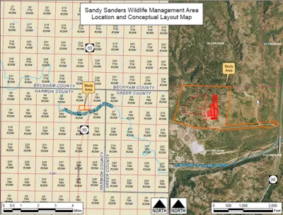
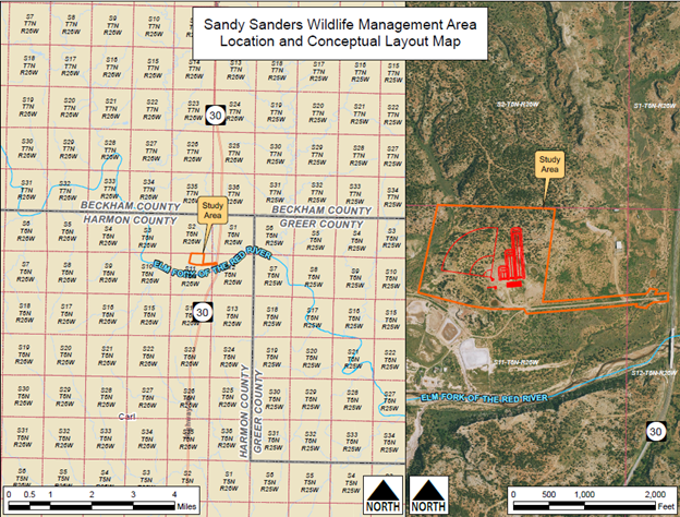
- Sandy Sander WMA Shooting Range
Location: Sandy Sanders WMA Shooting Range
Location Coordinates: 35.01267400802637, -99.9102041027259
Purpose: To provide an opportunity for the public to comment, identify specific issues, and/or environmental impacts that can be addressed in the Draft Environmental Assessment for the Oklahoma Department of Wildlife Conservation (ODWC).
Need: The proposed need is to complete an environmental assessment (EA) including environmental studies and to arrive at either a Finding of No Significant Impact (FONSI) or complete an Environmental Impact Study (EIS) pursuant to the National Environmental Policy Act (NEPA) for the project described below:
The construction of a new shooting range on Sandy Sanders WMA, located north of the Elm Fork Red River, approximately 16 miles south of Erick, Oklahoma and 5 miles east of the Oklahoma/Texas state limits. The site is located along OK-30 in Section 11, Township 6N, Range 26W.
Proposed plans may include a 200-yard rifle range, a 100-yard rifle range, and a 25-yard pistol range with covered metal shooting stations including shooting benches/tables, safety berms, and backstops, a shotgun trap range, an archery tower/range, access roads, parking lots, gates, fencing, ADA parking and pathways, restrooms, and borrow areas.
Estimated timeline to complete an environmental assessment, engineering, and construction is 3-5 years.
The shooting range is located on property owned by the Oklahoma Department of Wildlife Conservation (ODWC) and the project is funded by the ODWC and United States Fish and Wildlife Service (USFWS).
Comment Deadline:
Written comments to be provided or postmarked by April 15, 2025, via email, poll, mail, or social media comments.
Submit comments via email to: Amanda.thomas@odwc.ok.gov
Submit comments via mail to:
Oklahoma Department of Wildlife Conservation
Attn: Shooting Range Coordinator
P.O. Box 53465, Oklahoma City, OK 73152